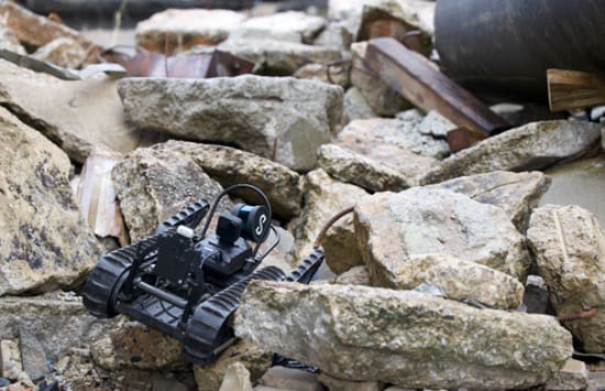
Teledyne FLIR Defense just leveled up its Third-Party Payload Integration Program by certifying Emesent’s Hovermap LiDAR for seamless use across drones, ground robots, and even radiation detection systems—unveiled at Modern Day Marine 2026. This isn’t just another gadget mashup; Hovermap’s GPS-denied mapping tech fuses real-time 3D scans with CBRN (chemical, biological, radiological, nuclear) visualizations, enabling rapid deployment in the blackest of blackouts or denied environments. Think urban canyons, underground bunkers, or jammed battlefields where traditional GPS fails—now operators get instant, actionable intel without skipping a beat.
For the 2A community, this is a stealthy game-changer that blurs the lines between military-grade autonomy and civilian self-reliance. While Teledyne pitches it for defense platforms, the modularity screams dual-use potential: pair this LiDAR with commercial drones or rugged UGVs, and you’ve got a private-sector force multiplier for ranchers scanning vast properties, hunters mapping dense woods sans GPS, or preppers hardening homesteads against real-world threats like wildfires or intrusions. In a post-Roe world of escalating civil unrest and natural disasters, tools like this empower decentralized defense—your backyard robot swarm could outmaneuver centralized response teams, turning shall not be infringed into shall not be outgunned by tech. Critics might cry militarization, but history shows innovation flows from defense to the people; this certification accelerates that pipeline, making elite autonomy accessible before Big Brother locks it down.
The implications ripple wide: as FLIR’s program grows, expect a flood of certified payloads democratizing autonomy for non-state actors. For 2A patriots, it’s a call to arms—stock up on compatible platforms now, because when SHTF and the grid blinks out, Hovermap-fused systems could mean the difference between reaction and domination. Teledyne’s move isn’t just expansion; it’s an open invitation to build the future of armed freedom, one LiDAR scan at a time.