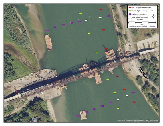
The Missouri River near Bismarck-Mandan is about to get a little tighter for boaters, and that squeeze carries a quiet but important lesson for anyone who values the right to keep and bear arms. When the North Dakota Game and Fish Department moves the navigation channel east of the BNSF bridge project before June 13, it isn’t just rerouting weekend anglers—it’s reminding every citizen how quickly a public waterway can be carved up by safety zones, buoys, and federal fines. The same regulatory reflex that turns a construction site into an idle-speed corridor can just as easily turn a shooting range into a restricted buffer or a hunting lease into a no-shoot zone if the political winds shift.
For the 2A community, the takeaway is straightforward: infrastructure projects and environmental rules rarely stay in their own lane. A temporary safety zone on the river today can become the precedent for permanent access restrictions tomorrow, and those restrictions often arrive under the banner of “public safety” rather than any honest debate about constitutional rights. North Dakota’s strong hunting and fishing culture makes the river a living classroom for how government manages shared spaces; if boaters learn to navigate the new channel without incident, they’ll also learn that vigilance over maps, buoys, and enforcement dates is the price of continued access.
The larger implication is that Second Amendment supporters cannot afford to treat river navigation notices as someone else’s problem. Every new layer of federal or state control over public land and water adds another data point to the argument that rights must be actively defended, not assumed. Whether the issue is a bridge project, a wildlife refuge expansion, or a proposed shooting-range buffer, the pattern is the same: control the map, control the access, control the culture. Staying alert to these small administrative moves keeps the larger constitutional landscape from shifting under our feet.